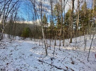
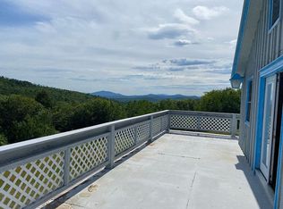
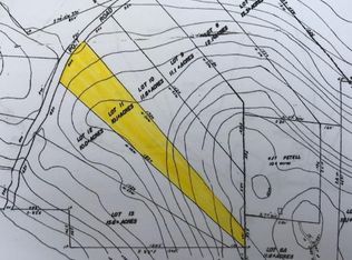
Access off of Ben Gilpatrick Road to this elevated property is currently via ATV, on foot, or horseback. Once there, you'll be treated to an amazing location with views for a hunting camp, or yurt. Aaron Williams Brook does run through the northerly part of this lot on its way to the 10 Mile River and the property hasn't been logged in years and has relatively mature forest. Ben Gilpatrick Road has been a 'town way' since 1852. It is maintained by the town year-round 250 yards from its intersection with Tripptown Road, and is maintained in summer-only by the Town 500 feet from Brownfield Road (Rt 160). The remaining portion between the two town road sections was discontinued in 1955 and the article to vote did not state to retain a public easement. It reverted back to the property owners to the center of the road on each side. Therefore, the condition and maintenance of the road are at the prerogative of the landowner using the road for access. The road is in decent condition a few hundred yards in from the main road. After that, it becomes rougher, suitable for an SUV, truck, or ATV. The road can be improved as desired, with collaboration with other landowners. Turning left onto 'old road' (see survey) the access becomes steeper as it climbs to the southerly property boundary. The subject land has a northerly aspect with the top elevation being a little over 1100ft above sea level.
Closed
$111,000
70AC Ben Gilpatrick Road, Hiram, ME 04041
--beds
--baths
70Acres
Land
Built in ----
70 Acres Lot
$-- Zestimate®
$--/sqft
$-- Estimated rent
Home value
Not available
Estimated sales range
Not available
Not available
Zestimate® history
Loading...
Owner options
Explore your selling options
What's special
Zillow last checked: 8 hours ago
Listing updated: September 04, 2025 at 08:32pm
Listed by:
Real Broker
Bought with:
Keller Williams Realty
Source: Maine Listings,MLS#: 1613045
Facts & features
Property
Parking
- Parking features: No Driveway, None
Features
- Has view: Yes
- View description: Mountain(s), Scenic, Trees/Woods
Lot
- Size: 70 Acres
- Features: Rural, Rolling Slope, Wooded
Details
- Zoning: Rural
Utilities & green energy
- Electric: No Electric
- Sewer: None
- Water: None
Community & neighborhood
Location
- Region: Hiram
Other
Other facts
- Road surface type: Gravel, Dirt
Price history
| Date | Event | Price |
|---|---|---|
| 9/4/2025 | Sold | $111,000-3.5% |
Source: | ||
| 1/23/2025 | Pending sale | $115,000 |
Source: | ||
| 1/23/2025 | Listing removed | $115,000 |
Source: | ||
| 10/7/2024 | Pending sale | $115,000 |
Source: | ||
| 7/25/2024 | Listed for sale | $115,000 |
Source: | ||
Public tax history
Tax history is unavailable.
Neighborhood: 04041
Nearby schools
GreatSchools rating
- 5/10Sacopee Valley Middle SchoolGrades: 4-8Distance: 3.5 mi
- 4/10Sacopee Valley High SchoolGrades: 9-12Distance: 3.5 mi
- 5/10South Hiram Elementary SchoolGrades: PK-3Distance: 3.6 mi