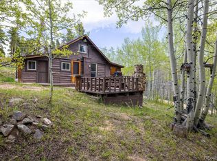
Raw land with unimproved cabin and shed. Top of Coal Creek Canyon west of Wondervu. Land is level on top then sloping down to Indian Peak Road to the east. Building lot determination was established Nov 2014. See on-line Boulder Co assessor record(s) for all the latest data. Boulder County account number = R0025997 Driving Directions: from hwy 93 and hwy 72. Highway 72 west 11 miles. Left (south) on Indian Peak Road. First left to upper Indian Peak Road. RE sign on RHS. Park in front of sign.
This property is off market, which means it's not currently listed for sale or rent on Zillow. This may be different from what's available on other websites or public sources.