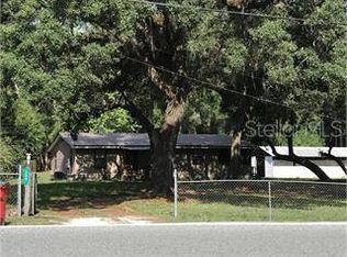
Industrial site in the path of tremendous growth, the property is surrounded by other industrial and commercial sites. Accessed by Anderson road, the property layout contains a portion of the previous railway bed that has frontage on US 301. Convenient access to The Villages, I75, and the Florida Turnpike. City of Coleman utilities. Location can't be beat for industrial usage.
Sold for $601,500 on 06/28/24
$601,500
1242 Anderson Rd, Coleman, FL 33521
--beds
0baths
14.23Acres
Industrial
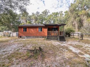
Built in 1967
14.23 Acres Lot
$514,800 Zestimate®
$418/sqft
$1,737 Estimated rent
Home value
$514,800
$391,000 - $659,000
$1,737/mo
Zestimate® history
Loading...
Owner options
Explore your selling options
What's special
Facts & features
Interior
Bedrooms & bathrooms
- Bathrooms: 0
Heating
- Electric
Interior area
- Total interior livable area: 1,440 sqft
Property
Parking
- Parking features: Carport
Features
- Exterior features: Wood
Lot
- Size: 14.23 Acres
- Features: In City Limits, Street One Way, Irregular Lot
Details
- Additional parcels included: F35D001
- Parcel number: F35D010
- Zoning: IND
Utilities & green energy
- Water: Public
- Utilities for property: Electricity Available, Water Available
Community & neighborhood
Location
- Region: Coleman
Other
Other facts
- Property Type: Land
- Total Acreage: 10 to less than 20
- Utilities: Electricity Available, Water Available
- Lot Features: In City Limits, Street One Way, Irregular Lot
- Road Frontage Type: City Street
- Current Adjacent Use: Industrial
- Flood Zone Code: X
- Water Access YN: 0
- Water Extras YN: 0
- Waterfront YN: 0
- Water View YN: 0
- Zoning Compatible YN: 1
- Public Survey Section: 35
- Additional Parcels YN: 1
- Waterfront Feet Total: 0
- Public Survey Range: 22
- Number Of Lots: 2
- Front Footage: 275
- For Lease YN: 0
- Flood Zone Panel: 12119C0137D
- Zoning: IND
- Property Sub Type: Industrial
- Water Source: Public
- Lot Size Dimensions: IRREGULAR
- Tax Year: 2019
- Flood Zone Date: 2013-09-27
- Additional Parcels Description: F35D001
- List Office URL: http://www.oxfordland.com
- Tax Annual Amount: 2042.81
Price history
| Date | Event | Price |
|---|---|---|
| 6/28/2024 | Sold | $601,500+46.4%$418/sqft |
Source: Public Record | ||
| 12/16/2022 | Sold | $411,000-53.8%$285/sqft |
Source: Public Record | ||
| 9/30/2021 | Listing removed | -- |
Source: | ||
| 4/29/2021 | Listed for sale | $889,375$618/sqft |
Source: | ||
| 1/19/2021 | Listing removed | -- |
Source: | ||
Public tax history
| Year | Property taxes | Tax assessment |
|---|---|---|
| 2024 | $1,698 +36.1% | $89,590 +10% |
| 2023 | $1,248 -26.8% | $81,450 -28.8% |
| 2022 | $1,706 -9.9% | $114,450 |
Find assessor info on the county website
Neighborhood: 33521
Nearby schools
GreatSchools rating
- 8/10Lake Panasoffkee Elementary SchoolGrades: PK-5Distance: 3.5 mi
- 3/10Wildwood Middle/ High SchoolGrades: 6-12Distance: 5 mi